File size: 7.8 MB
The flight planning features in SkyDemon are all designed to make planning a flight less tedious and more interesting, by brig the very best aeronautical briefing information directly to your fingertips in real as you explore our charts and expent with potential journeys.
SkyDemon will help give you the confidence to fly further and to more interesting places. Plan a journey, brief yourself on potential hazards, prepare for flight and analyse your track logs. Live briefing data includes NOTAM, airfield documents and maps, TAF, METAR and wind forecasts at altitude.
Dynamic Vector Charts
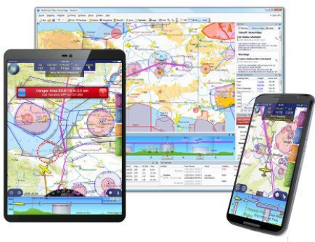
Our charts are widely recognised as being the clearest aeronautical charts available. They are entirely bespoke, created by us every 28 days (at least) directly from raw aeronautical data published by the countries we cover. This means that wherever you fly, the look and feel of your chart is consistent.
Comprised of many individually selectable layers and adjustable to your preferences, they show you only what you need to see and nothing else. Unlike printed charts, a SkyDemon chart is aware of your plans and can dynamically hide airspace and other features not relevant at the levels you are flying. This makes it much easier to interpret, and as a result, safer.
There is a high level of interactivity in our charts. Many details which might in the past have been written permanently on your map are now completely hidden until asked for, by simply moving the mouse or touching with your finger. Practically every charted item can reveal extra information, whether it's the vertical boundaries or activity s of airspace, the frequencies for an airfield or the height of a ground-based obstruction.
Best of all, because our charts are created and owned by us, they are all included as part of your subscription. We have charting for all of Europe, southern Africa, New Zealand and the USA.
Route Planning Made Easy
Planning a route with SkyDemon is as simple as clicking on, or touching, consecutive waypoints on the map. This intuitive method of route planning was pioneered by SkyDemon and is one of the hallmarks of our software's simplicity of use. Once configured, the route can easily be adjusted by dragging legs to create diversions. In this way you may find yourself planning many fantasy flights of the future.
As you plan, SkyDemon obtains all the briefing information necessary for your flight in real (more about that below) so that accurate readings of total distance and are always available. Some of this information is used to create the Pilot Log, which you can view or print at any and includes essential information like which headings to fly and your minimum safe altitudes. It also includes enroute frequencies and radio navigation aids you are likely to use.
You will see warnings displayed in real as you plan. Warnings include penetration of controlled or dangerous airspace, a temporary restricted area created by NOTAM, and planning to fly a leg lower than is safe. As with our charts, the types of warnings shown are configurable to your own preferences.
download скачать
https://nitroflare.com/view/6944B10C59742F2/jnveg.SkyDemon.3.15.5.rar
https://rapidgator.net/file/a773f2545fead58cea671dbbe41c71ac/jnveg.SkyDemon.3.15.5.rar