Object-based image analysis & classification in QGIS/ArcGIS
Video: .mp4 (1280x720, 30 fps(r)) | Audio: aac, 44100 Hz, 2ch | Size: 2.35 GB
Genre: eLearning Video | Duration: 33 lectures (3 hour, 35 mins) | Language: English
Learn image segmentation, object-based image analysis (OBIA) & object-based image classification in QGIS & ArcGIS
What you'll learn
Learn image segmentation, object-based image analysis (OBIA) & object-based image classification in QGIS & ArcGIS
Advance your skills in QGIS and ArcGIS
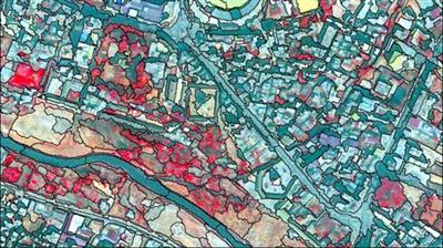
Understand the concept of segmentation and object-based image analysis
Learn theory and practise behind land use & land cover mapping
Learn how to work with the variety of remote sensing data streams (UAV data. satellite images)
Apply segmentation and object-based image classification in QGIS (OTB) and ArcGIS
You'll have a copy of the labs, step-by-step manuals and scripts used in the course for QGIS and ArcGIS & more
Conduct your independent OBIA projects in QGIS & ArcGIS
Requirements
Basic knowledge of manipulating spatial (image) data will be an advantage
A working computer with internet connection
The course will be demonstrated using a Windows PC. Mac and Linux users will have to adapt the instructions to their operating systems.
Description
Object-based Land Use / Land Cover mapping with Machine Learning and Remote Sensing Data in QGIS ArcGIS
This course is designed to take users who use QGIS & ArcGIS for basic geospatial data/GIS/Remote Sensing analysis to perform more advanced geospatial analysis tasks including segmentation, object-based image analysis (OBIA) for land use, and land cover (LULC) tasks using a variety of different data, and applying Machine Learning state of the art algorithms. In addition to level up your skills in QGIS, ArcGIS for spatial data analysis, you will be introduced to a powerful opportunity to learn how to use ArcGIS also for advanced satellite-based image analysis for the most demanded task in Remote Sensing, that is land use and land cover mapping.
I'm very excited that you found my intermediate to advance object-based image analysis for the LULC mapping course. This course is designed to equip you with the practical knowledge of advanced Land Use and Land Cover (LULC) mapping, which is one of the core skills for any Geographic Information Systems (GIS) and Remote Sensing analyst. By the end of the course, you will feel confident and completely understand and apply advanced Geospatial analysis including performing Machine Learning algorithms for land use and land cover mapping and learning object-based image analysis and basics of segmentation. All this you will be able to carry out on the real data in one of the most popular GIS software which is ArcGIS and QGIS.
Please, note: this course is best suited for the users with the basic knowledge of Remote Sensing image analysis.
This course is different from other training resources. Each lecture seeks to enhance your GIS and Remote Sensing skills in a demonstrable and easy-to-follow manner and provide you with practically implementable solutions. You'll be able to start analyzing spatial data for your own projects, and gain appreciation from your future employers with your advances GIS skills and knowledge of the cutting edge LULC techniques.
In the course, you will be able to learn the theory behind OBIA and LULC mapping, as well as basics information on how to work with the satellite images. I will show you how to perform image segmentation in QGIS/ ArcGIS and how to carry out all stages of object-based LULC mapping. I also will show you how to apply OBIA for a real-life example of an object-based crop classification task with the real project-data. All image classification routines we will implement using state-of-the-art Machine Learning algorithms such as Random Forest and Support Vector Machines.
The course is ideal for professionals such as geographers, programmers, social scientists, geologists, GIS, and Remote Sensing experts and all other experts who need to use LULC maps in their field and would like to learn the fundamentals of LULC and change detection in GIS. If you're planning to undertake a task that requires to use a state of the art classification algorithms for creating, for instance, land cover and land use maps, this course will give you the confidence you need to understand and solve such geospatial problem.
One important part of the course is the practical exercises. You will be given some precise instructions, codes, and datasets to create LULC maps and change maps using the ArcGIS & QGIS software
INCLUDED IN THE COURSE: You will have access to the data used in the course, along with the Java code files. You will also have access to future resources. Enroll in the course today & take advantage of these special materials!
Who this course is for:
Geographers, Programmers, geologists, biologists, social scientists, or everyone who deals with GIS maps in their field or would like to learn GIS and Remote Sensing
download скачать link:
https://rapidgator.net/file/448119b46e8b9ebabd7d1b3d6667f303/n6bl9.Objectbased.image.analysis..classification.in.QGISArcGIS.rar.html


https://nitroflare.com/view/FC55A927C32EBD4/n6bl9.Objectbased.image.analysis..classification.in.QGISArcGIS.rar


https://alfafile.net/file/8QWeS/n6bl9.Objectbased.image.analysis..classification.in.QGISArcGIS.rar
Links are Interchangeable - No Password - Single Extraction